


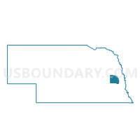
Ashland W2 Voting District, Saunders County, Nebraska
About
Outline

Summary
| Unique Area Identifier | 613881 |
| Name | Ashland W2 Voting District |
| County | Saunders County |
| State | Nebraska |
| Area (square miles) | 0.38 |
| Land Area (square miles) | 0.38 |
| Water Area (square miles) | 0.00 |
| % of Land Area | 100.00 |
| % of Water Area | 0.00 |
| Latitude of the Internal Point | 41.04120690 |
| Longtitude of the Internal Point | -96.38085420 |
Maps


Graphs
Select a template below for downloading or customizing gragh for Ashland W2 Voting District, Saunders County, Nebraska


